Historical Maps: Difference between revisions
From All Skies Encyclopaedia
No edit summary |
No edit summary |
||
| Line 8: | Line 8: | ||
| |
| |
||
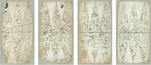
==== Dürer (1515) ==== |
==== Dürer (1515) ==== |
||
|[[File:Duerer1515 both 300dpi.jpg|thumb|celestial maps (north, south)]] |
|||
| |
|||
|- |
|- |
||
| |
| |
||
| Line 24: | Line 24: | ||
| |
| |
||
==== Lacaille (1763) ==== |
==== Lacaille (1763) ==== |
||
|[[File:Lacaille 1763.png|thumb|screenshot of [https://www.e-rara.ch/zut/content/zoom/197200?lang=en zoomable map at library in Zurich]]] |
|||
| |
|||
|} |
|} |
||
[[Category:Service]] |
[[Category:Service]] |
||
Revision as of 20:06, 19 September 2024
Here is a gallery of the historical maps that we are frequently referring to and display details of.
| author (year) | image |
|---|---|
Dürer (1515) |
|
van der Keere & Plancius (1612) |
|
Habrecht (1621) |
|
Royer (1679) |
|
Lacaille (1763) |
 screenshot of zoomable map at library in Zurich |


