Historical Maps: Difference between revisions
From All Skies Encyclopaedia
(added Royer (1679)) |
No edit summary |
||
| Line 6: | Line 6: | ||
!image |
!image |
||
|- |
|- |
||
| |
|||
| ⚫ | |||
==== Dürer (1515) ==== |
|||
| |
|||
|- |
|||
| |
|||
| ⚫ | |||
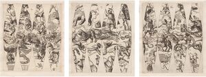
|[[File:KEE all.JPG|thumb|globe gores]] |
|[[File:KEE all.JPG|thumb|globe gores]] |
||
|- |
|- |
||
| |
|||
==== Habrecht (1621) ==== |
|||
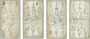
|[[File:Habrecht1621 GlobeGores.jpg|thumb|globe gores]] |
|[[File:Habrecht1621 GlobeGores.jpg|thumb|globe gores]] |
||
|- |
|- |
||
| |
|||
|Royer |
|||
==== Royer (1679) ==== |
|||
|[[File:Royer south.jpg|thumb|Celestial south map by Augustin Royer (1679)]] |
|[[File:Royer south.jpg|thumb|Celestial south map by Augustin Royer (1679)]] |
||
|- |
|- |
||
| |
|||
|Lacaille |
|||
==== Lacaille (1763) ==== |
|||
| |
| |
||
|} |
|} |
||


