Historical Maps: Difference between revisions
From All Skies Encyclopaedia
(entered two maps (Keere+Plancius, Habrecht)) |
No edit summary |
||
| (5 intermediate revisions by the same user not shown) | |||
| Line 1: | Line 1: | ||
Here is a gallery of the historical maps that we are frequently referring to and display details of. |
Here is a gallery of the historical maps that we are frequently referring to and display details of. |
||
== Interactive digitals Maps and Globes == |
|||
*Chinese [http://www.chinesehsc.org/chinese_astronomy.shtml Suzhou Map] (13th century with older data) |
|||
*[https://digicult2.thulb.uni-jena.de/rsc/viewer/digicult_derivate_00115090/Sternkarte2.tif 1395 Korean Map] (Uni Jena) |
|||
*[https://homepage.univie.ac.at/georg.zotti/virtual_globes/modelviewer.html?obj=globes/1279_al-Urdi/1279_al-Urdi.obj 1279 al-Urdi's Celestial Globe] |
|||
*[https://homepage.univie.ac.at/georg.zotti/virtual_globes/modelviewer.html?obj=globes/1626_Greuter_Sky/1626_Greuter_Sky.obj 1626 Nicolai&Greuter's Celestial Globe] |
|||
*[https://homepage.univie.ac.at/georg.zotti/virtual_globes/modelviewer.html?obj=globes/1688_Coronelli_Sky/1688_Coronelli_Sky.obj 1688 Coronelli's Celestial Globe] |
|||
*[https://homepage.univie.ac.at/georg.zotti/virtual_globes/modelviewer.html?obj=globes/1792_Cassini_Sky/1792_Cassini_Sky_optLayout.obj 1792 Cassini's Celestial Globe] |
|||
== Table of Resources == |
|||
{| class="wikitable" |
{| class="wikitable" |
||
|+ |
|+ |
||
| Line 6: | Line 15: | ||
!image |
!image |
||
|- |
|- |
||
| |
|||
| ⚫ | |||
==== Dürer (1515) ==== |
|||
|[[File:Duerer1515 both 300dpi.jpg|thumb|celestial maps (north, south)]] |
|||
|- |
|||
| |
|||
==== Mercator (1551) ==== |
|||
|[[File:Mercator1551 all 300dpi.png|thumb|globe gores ([https://trove.nla.gov.au/ TROVE])]] |
|||
|- |
|||
| |
|||
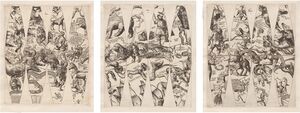
| ⚫ | |||
|[[File:KEE all.JPG|thumb|globe gores]] |
|[[File:KEE all.JPG|thumb|globe gores]] |
||
|- |
|- |
||
| |
|||
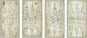
==== Habrecht (1621) ==== |
|||
|[[File:Habrecht1621 GlobeGores.jpg|thumb|globe gores]] |
|[[File:Habrecht1621 GlobeGores.jpg|thumb|globe gores]] |
||
|- |
|- |
||
|Royer |
|||
| |
| |
||
==== Royer (1679) ==== |
|||
|[[File:Royer south.jpg|thumb|Celestial south map by Augustin Royer (1679)]] |
|||
|- |
|- |
||
|Lacaille |
|||
| |
| |
||
==== Lacaille (1763) ==== |
|||
|[[File:Lacaille 1763.png|thumb|screenshot of [https://www.e-rara.ch/zut/content/zoom/197200?lang=en zoomable map at library in Zurich]]] |
|||
|} |
|} |
||
[[Category:Service]] |
[[Category:Service]] |
||
Latest revision as of 06:28, 5 November 2024
Here is a gallery of the historical maps that we are frequently referring to and display details of.
Interactive digitals Maps and Globes
- Chinese Suzhou Map (13th century with older data)
- 1395 Korean Map (Uni Jena)
- 1279 al-Urdi's Celestial Globe
- 1626 Nicolai&Greuter's Celestial Globe
- 1688 Coronelli's Celestial Globe
- 1792 Cassini's Celestial Globe
Table of Resources
| author (year) | image |
|---|---|
Dürer (1515) |
|
Mercator (1551) |
 globe gores (TROVE) |
van der Keere & Plancius (1612) |
|
Habrecht (1621) |
|
Royer (1679) |
|
Lacaille (1763) |
 screenshot of zoomable map at library in Zurich |


